Hierarchical accompanying and inhibiting patterns on the spatial arrangement of taxis' local hotspots
Hierarchical accompanying and inhibiting patterns on the spatial arrangement of taxis' local hotspots
Xiao-Jian Chen, Changjiang Xiao, Zhou Huanga, Keli Wang, Weiyu Zhang, Yu Liu
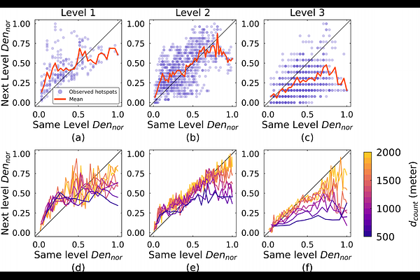
AbstractDue to the large volume of recording, the complete spontaneity, and the flexible pick-up and drop-off locations, taxi data portrays a realistic and detailed picture of urban space use to a certain extent. The spatial arrangement of pick-up and drop-off hotspots reflects the organizational space, which has received attention in urban structure studies. Previous studies mainly explore the hotspots at a large scale by visual analysis or some simple indexes, where the hotspots usually cover the entire central business district, train stations, or dense residential areas, reaching a radius of hundreds or even thousands of meters. However, the spatial arrangement patterns of small-scale hotspots, reflecting the specific popular pick-up and drop-off locations, have not received much attention. Using two taxi trajectory datasets in Wuhan and Beijing, China, this study quantitatively explores the spatial arrangement of fine-grained pick-up and drop-off local hotspots with different levels of popularity, where the sizes are adaptively set as 90m*90m in Wuhan and 105m*105m in Beijing according to the local hotspot identification method. Results show that popular hotspots tend to be surrounded by less popular hotspots, but the existence of less popular hotspots is inhibited in regions with a large number of popular hotspots. We use the terms hierarchical accompany and inhibiting patterns for these two spatial configurations. Finally, to uncover the underlying mechanism, a KNN-based model is proposed to reproduce the spatial distribution of other less popular hotspots according to the most popular ones. These findings help decision-makers construct reasonable urban minimum units for precise traffic and disease control, as well as plan a more humane spatial arrangement of points of interest.